
COMPARE THE ROUTES
I&M says it wants to minimize impacts. The public deserves to see the data.
Compare the Routes
I&M is considering several possible routes for the Lulu-Sorenson transmission line, and the final route has not yet been selected.
But these aren't just lines on a map. Each route will have a real impact on the people, land and natural resources of Steuben and DeKalb Counties.
Before a final route is selected, we believe I&M should clearly compare the alternatives and answer some basic questions:
How many homes and properties will be affected?
How much farmland will be impacted?
How many lakes, wetlands, streams and other natural areas could be affected?
Are there historic or Native American sites along the route?
Could the route follow existing roads and property boundaries instead of cutting through private property?
Most importantly, is there another route that would cause less overall impact?
I&M says its goal is to avoid or minimize impacts to people and the environment. We simply want to see the information showing how each route measures up.
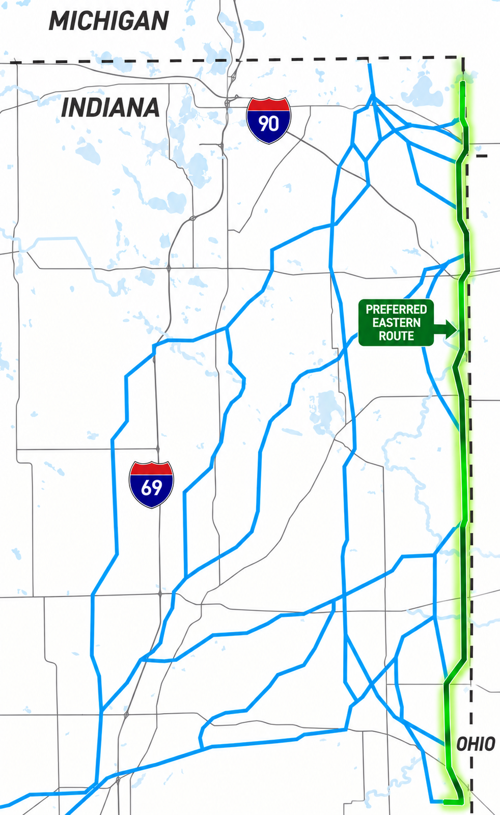
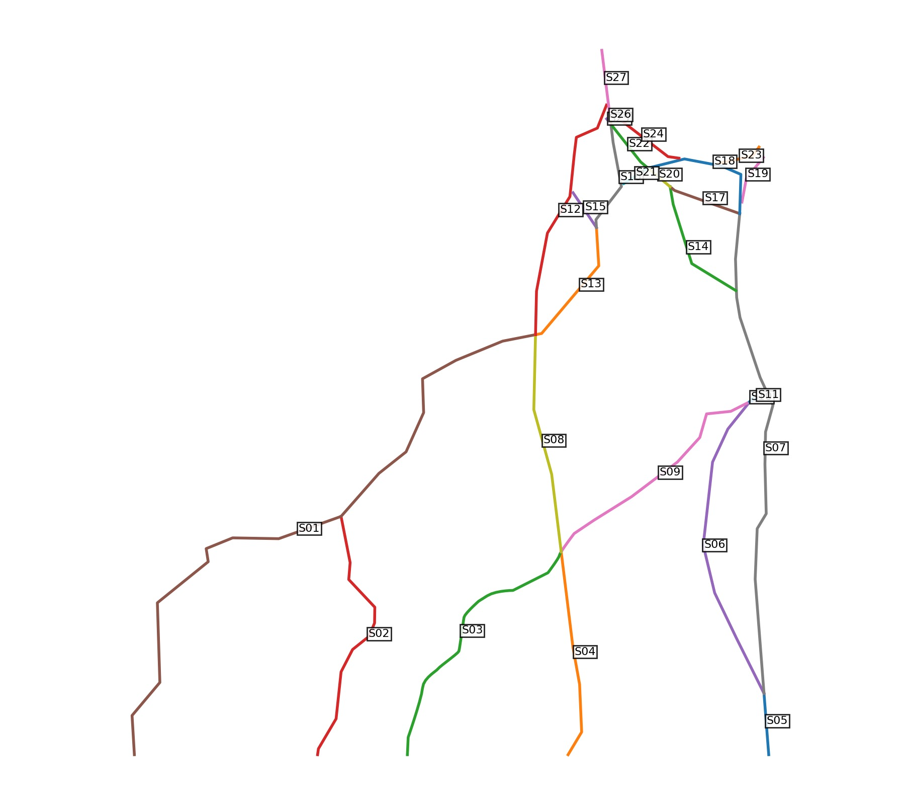
The attached map shows the proposed routes, with our preferred route being the Eastern most segments along the Indiana-Ohio state-line corridore. The information on this page explains some of the most important factors we believe I&M should consider before making its final decision.
8 Questions I&M Should Answer Before Choosing a Route
1. What Lakes, Wetlands & Waterways Would Each Route Affect?
Before choosing a route, I&M should clearly show what natural resources could be affected by each alternative, including:
Lakes and ponds
Wetlands
Streams and tributaries
Floodplains and floodways
Watersheds
Natural buffers around waterways
Proposed tower locations and construction access roads
And we shouldn't look only at places where the transmission line actually crosses water. Construction near a wetland, stream or lake can also matter because of clearing, grading, runoff, erosion and changes to drainage.
The simple question: Which route affects the fewest lakes, wetlands and waterways?
2. What Environmental Studies Are Being Done BEFORE a Route Is Chosen?
This is an important question because of I&M's current timeline.
I&M expects to identify a proposed route in late 2026, but its more detailed field surveys and engineering are scheduled for 2027. Those later surveys will look for wetlands, floodplains, forests, wildlife habitat and other environmental concerns.
So what information is being used to compare the routes before one is selected?
And if the later surveys discover an important wetland, habitat or other natural resource, could that cause I&M to change the route?
3. Can Environmental Damage Be Avoided in the First Place?
This may be one of the most important questions.
Environmental protection shouldn't begin with:
"How do we fix the damage?"
It should begin with:
"Can we avoid the damage?"
Indiana environmental guidance generally follows three steps when regulated waters are affected:
1. Avoid the impact.
2. Minimize the impact.
3. Address impacts that truly cannot be avoided.
So if one reasonable route affects an important wetland, stream or lake area and another route avoids it, why wouldn't I&M choose the route that avoids the impact?
4. How Do the Routes Compare Side by Side?
Residents shouldn't have to look at a map and guess which route has the least impact.
I&M should provide a simple comparison showing things such as:
Number of homes and properties affected
Miles through lake watersheds
Lake and waterbody crossings
Stream crossings
Wetlands affected
Floodplain and floodway crossings
Acres of trees and vegetation that would need to be cleared
New right-of-way versus existing corridors
Tower locations near wetlands and waterways
Temporary and permanent construction roads
Natural resources each route successfully avoids
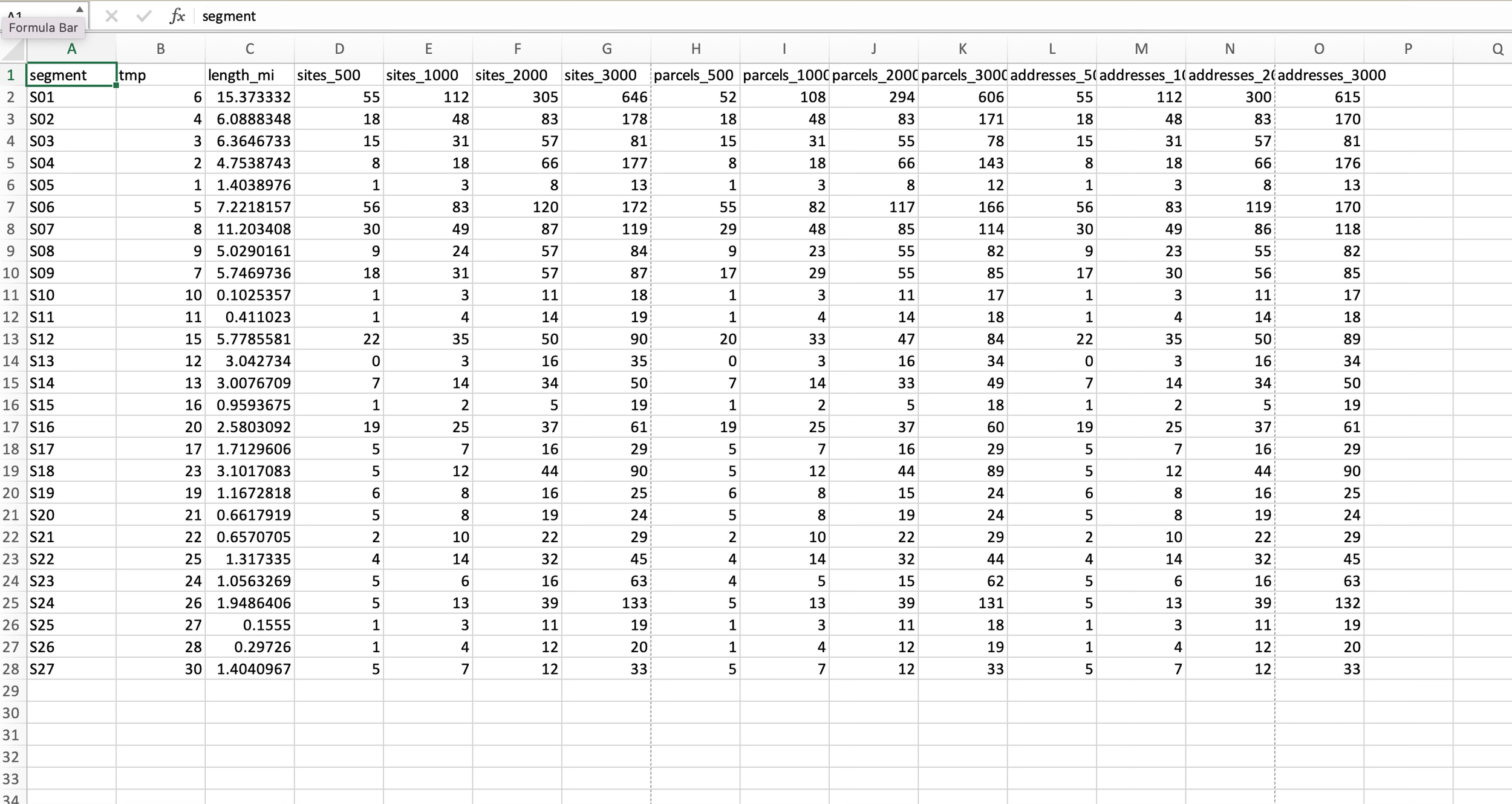
The environmental material originally proposed many of these measurements. I would expand the comparison beyond environmental resources to include people, homes, farms and private property as well.
Put the routes side by side and let everyone see the differences.
5. What Is the Total Impact on Our Lakes?
A lake isn't just the water inside its shoreline.
Wetlands, streams, drainage areas and surrounding land can all be connected to the health of a lake.
Construction could involve clearing trees, disturbing soil, building access roads, crossing streams and changing drainage. When several of these things happen within the same watershed, we believe I&M should consider their combined impact, rather than looking at every individual disturbance separately.
This is especially important in Steuben County, where lakes and connected waterways are such an important part of our communities.
6. Where Will the Towers & Construction Roads Go?
The impact isn't limited to the towers and power lines.
Building a transmission line this large may also require:
Large tower foundations
Construction work areas
Heavy equipment access
Temporary or permanent access roads
Tree and vegetation clearing
Grading
Stream and wetland crossings
Federal permitting rules even specifically address transmission-line access roads and tower foundations when they affect federally regulated waters.
We want to see the entire construction footprint—not just a line drawn on a map.
7. How Will Our Lakes & Streams Be Protected During Construction?
Clearing, grading and excavation can create runoff and sediment that eventually reaches streams, wetlands and lakes.
Indiana's construction stormwater requirements include measures intended to control sediment and protect natural features and buffers around waterways.
Before construction begins, residents should know:
Where will construction happen near water? What natural buffers will be removed? What protections will be used? And where will that runoff ultimately go?
8. Will I&M Show Us the Environmental Data BEFORE Making Its Decision?
This is really what this entire page comes down to.
Before committing to a route, we believe I&M should make the information it used to compare the alternatives available to the public, including:
Route comparison maps
Wetland and waterway information
Environmental studies
Stream and water crossings
Floodplain information
Construction access plans
Environmental criteria used to compare routes
Expected environmental permits
An explanation of why the selected route has less overall impact than the alternatives
The public shouldn't have to wait until after a route has been chosen to learn why it was selected.
Our Position
We understand that the Lulu-Sorenson transmission project is moving forward.
Our concern is where it goes.
AEP says its goal when choosing transmission routes is to avoid or minimize impacts to people and the environment as much as possible.
We believe the easternmost corridor along the Indiana-Ohio state line deserves serious consideration because it may provide an opportunity to keep this massive project away from more homes, established communities, lakes, wetlands and other important resources.
But we don't simply want I&M to tell us which route is best.
Show us the data. Compare the routes. Choose the route with the least overall impact.
Cost Is Not the Only Cost
The cheapest route to build isn't necessarily the route with the least impact.
I&M is part of American Electric Power (AEP), a publicly traded, investor-owned utility. Like other investor-owned utilities, AEP invests in infrastructure and earns regulated returns on those investments.
There is nothing unusual about that. But it is important to remember that the company building the transmission line and the communities affected by it don't necessarily look at "cost" the same way.
I&M has to consider what a route will cost to build.
Residents also have to consider what that route could cost our homes, farms, lakes, land and communities.
Both should matter.
The Line and the Route Are Two Different Questions
The decision has been made that additional transmission infrastructure is needed in the region.
But that doesn't answer another important question:
Where should the line go?
I&M is considering multiple possible routes for the Lulu-Sorenson transmission line. Choosing between them involves much more than simply finding a route that can be built.
AEP says its route-selection process considers impacts on people, natural resources and cultural resources, along with engineering, practicality and cost.
So yes, cost matters.
But it shouldn't be the only cost that matters.
A Cheaper Route Can Still Cost a Community More
The construction cost of a route is fairly easy to put on a spreadsheet.
Other costs aren't so easy to measure.
Homes & Families
How many homes will have a new 765-kV transmission corridor nearby?
Private Property
How many landowners will have new easements placed across their property?
Farms
How many farms will be crossed by the line? Where will towers and access roads go? Will the route interfere with drainage or farming operations?
Lakes, Wetlands & Waterways
How many lakes, streams, wetlands and watersheds could be affected by clearing, grading, construction and access roads?
Our Landscape
Where will a new 180–200-foot-wide transmission corridor be created through areas that don't have one today?
Parks & Recreation
Will the route affect parks, trails, lakes or other places people use and enjoy?
Historic & Cultural Resources
Are there historic, archaeological or Native American resources that could be affected?
Future Development
How could the route affect how land is used, developed or preserved in the future?
Some of these impacts are difficult to put into dollars.
That doesn't mean they don't have a cost.
Show Us the Comparison
Before I&M selects a route, we believe the public should be able to see how the alternatives compare.
For each serious route alternative, show us:
PEOPLE & PROPERTY
How many homes and properties are affected? How close does the line come to homes? How many new easements would be needed?
FARMLAND
How much farmland is crossed? How many farms would have towers or new access roads?
LAKES & WATERWAYS
How many lakes, wetlands, streams, floodplains and watersheds could be affected?
NATURAL RESOURCES
How much clearing would be required? What forests, wildlife habitat or other sensitive areas could be affected?
EXISTING CORRIDORS
Where can roads, property boundaries, existing utility corridors or easements be used to reduce the impact on private property?
COMMUNITY & CULTURAL RESOURCES
What parks, recreational areas, historic sites, archaeological areas and other community resources could be affected?
FUTURE LAND USE
How could each route affect existing and future development?
ENGINEERING
Are there engineering issues that make one route more difficult than another?
COST
What is the estimated cost of each alternative?
And then answer the most important question:
How were all of these factors weighed against each other?
If Cost Changes the Decision, Show Us
Let's say one route costs more to build but would avoid significantly more homes, farms, lakes or other important resources.
That doesn't automatically mean I&M should choose the more expensive route.
But the public should be able to see the tradeoff.
How much more would it cost?
What impacts would be avoided?
Why was one route ultimately selected over the other?
If cost plays a major role in rejecting a lower-impact route, tell us that and show us the numbers.
This Isn't About Accusing I&M of Doing Something Wrong
We aren't claiming I&M has already chosen the cheapest route.
And we aren't arguing that a for-profit utility shouldn't make money from building and operating infrastructure.
We're asking for transparency.
The company will make the route decision, but property owners and communities will live with many of its consequences for decades.
That's why the public should be able to understand how and why the final route was selected.
What Does Each Route Really Cost?
That's the question we believe should guide this discussion.
Some costs are paid by the utility.
Some may ultimately be paid through electric rates.
Others are borne by property owners, farmers and communities.
And some could last for generations through permanent changes to our land and landscape.
All of those costs deserve to be part of the conversation.
What We're Asking I&M to Do
Before selecting its route, we are asking I&M to:
Show us the serious route alternatives.
Show us the criteria used to compare them.
Show us the impact of each route.
Show us the estimated cost differences.
Explain how those factors were weighed.
Explain when cost or engineering caused a lower-impact option to be rejected.
Show us how public input was considered.
AEP says its goal is to avoid or minimize impacts to people and the environment as much as possible.
We aren't asking I&M to simply tell us it chose the most responsible route. We're asking them to show us why.
Talking Points
You can use the following talking points in your own personalized letter to I&M. You do not need to include everything below, but choose the points that apply to you and put them in your own words.
Support the Eastern State-Line Corridor. First and foremost, tell I&M that you support the outermost eastern study-segment corridor along the Indiana-Ohio state line and ask that it be given serious consideration as the final route.
Impact Fewer People. Keeping the transmission corridor toward the eastern edge of Steuben and DeKalb Counties may reduce the number of established communities and residential areas affected compared with routes that travel farther into the counties. Ask I&M to compare the alternatives based on the number of residences, properties and communities affected—not simply distance.
Protect Lakes, Wetlands & Natural Resources. Interior routes travel through areas filled with lakes, wetlands, streams, forests, wildlife habitat and nature preserves. Ask I&M to choose the route that minimizes impacts on these resources. I&M itself identifies wetlands, floodplains, forests, habitats and other ecological concerns as part of its environmental survey process.
Protect Historic & Native American Resources. Ask I&M to avoid areas with known or potential archaeological and cultural resources. This is especially important in the Ball Lake/Hamilton Lake area, where local historical and archaeological evidence should be fully investigated before a route is selected. I&M says it will investigate proposed routes for historic and Native American artifacts and other culturally important sites. Indiana's historic preservation agency also reviews projects that could affect archaeological or historic resources.
Follow Established Boundaries & Infrastructure Where Possible. Ask I&M to favor routes that follow existing roads, parcel boundaries and established infrastructure corridors rather than unnecessarily cutting new corridors through the interiors of farms and private properties. AEP identifies existing infrastructure—including roads, power lines, railroads and pipelines—as a routing consideration on its Indiana transmission projects.
Protect Farms & Private Property. I&M says this project could require a 180–200-foot-wide right-of-way, with structures approximately 1,200 feet apart. Ask I&M to minimize the number of farms and private properties that are divided or otherwise substantially affected by the corridor.
Consider the Long-Term Impact. This infrastructure will remain for generations. Ask I&M to consider not only construction costs, but also long-term impacts on property use, future development, agriculture, scenic views, recreational areas and community character.
The Main Message to Consider in Your Letter
We know the line is coming, but the route has not yet been chosen. Please select the outermost eastern corridor along the Indiana-Ohio state line and minimize the overall impact on Steuben and DeKalb Counties.
SEND A LETTER
I&M is accepting public feedback through October 9, 2026.
Your letter does not need to be long. Tell I&M that you support the outermost eastern/state-line corridor and explain why. Here are some sample letters you can use to begin your own, personal letter:
Sample 1 — Short & Simple
Subject: Please Select the Eastern State-Line Corridor
Dear I&M Lulu-Sorenson Project Team,
I am writing regarding the Lulu-Sorenson Transmission Improvements Project. I encourage I&M and AEP Transmission to select the outermost eastern study-segment corridor along the Indiana-Ohio state line.
If this transmission line must be built, I believe the route should impact the fewest communities, people, homes, farms, lakes and natural resources possible. Keeping the line toward the eastern edge of Steuben and DeKalb Counties appears to provide an opportunity to reduce the impact on established communities and avoid bringing this massive infrastructure farther into our counties.
Please give the eastern state-line corridor serious consideration when selecting the final route.
Thank you,
[NAME]
[CITY/COUNTY]
Sample 2 — Resident / Property Owner
Subject: Support the Eastern State-Line Corridor
Dear I&M Lulu-Sorenson Project Team,
As a resident/property owner in [Steuben/DeKalb] County, I am asking I&M to select the outermost eastern corridor along the Indiana-Ohio state line for the Lulu-Sorenson project.
The proposed transmission line will have a permanent impact on whichever communities it crosses. I believe the final route should minimize the number of residents and properties affected and avoid unnecessarily bringing the corridor through established residential and lake communities.
Please compare the routes based on their total impact on communities, homes, private property, lakes, wetlands, natural areas and future development. Where possible, I also encourage I&M to follow existing roads and established boundaries rather than cutting new corridors through the interiors of private properties.
Please keep the final route toward the eastern edge of Steuben and DeKalb Counties.
Sincerely,
[NAME]
[ADDRESS OR COMMUNITY]
Sample 3 — Farmer / Landowner
Subject: Lulu-Sorenson Route Selection and Agricultural Land
Dear I&M Lulu-Sorenson Project Team,
I am writing to encourage I&M and AEP Transmission to select the outermost eastern/state-line corridor for the Lulu-Sorenson project.
As a landowner/farmer, I am particularly concerned about the impact a 180–200-foot transmission right-of-way could have on agricultural property. New transmission corridors can divide properties, affect future land-use decisions and create long-term restrictions associated with towers, access, and easements.
I ask I&M to select a route that minimizes the number of private properties and farms affected and, where feasible, follows existing roads, parcel boundaries and established corridors rather than unnecessarily cutting through the interiors of properties.
For these reasons, please give serious consideration to keeping the project along the eastern edge of Steuben and DeKalb Counties near the Indiana-Ohio state line.
Sincerely,
[NAME]
[PROPERTY/FARM LOCATION]
Sample 4 — Steuben Lakes & Natural Resources
Subject: Protect Steuben and DeKalb County Natural Resources
Dear I&M Lulu-Sorenson Project Team,
I am asking I&M to select the outermost eastern corridor along the Indiana-Ohio state line rather than routes that travel farther into Steuben and DeKalb Counties.
Steuben County is especially defined by its lakes, wetlands, streams, forests and wildlife habitat. These resources are important environmentally, recreationally and economically. A major transmission corridor could permanently change the areas through which it passes.
Please select the route that minimizes crossings and impacts involving lakes, wetlands, streams, nature preserves, wooded areas and established lake communities. I also ask that archaeological and cultural resources, including areas with known Native American history (like near Ball Lake in Hamilton, IN), receive careful consideration before a final route is selected.
I believe keeping the project toward the eastern edge of the counties deserves serious consideration as the lower-impact alternative.
Thank you,
[NAME]
[CITY/COUNTY]
Sample 5 — More Comprehensive
Subject: Request to Select the Eastern State-Line Corridor
Dear I&M and AEP Transmission Leadership,
I am writing regarding the final route selection for the Lulu-Sorenson Transmission Improvements Project. I understand that the project is moving forward, but that the final route has not yet been selected.
I strongly encourage you to give serious consideration to the outermost eastern study-segment corridor along the Indiana-Ohio state line through Steuben and DeKalb Counties.
When comparing the alternatives, please consider which route affects the fewest residents and established communities; minimizes impacts on lakes, wetlands, streams and wildlife habitat; avoids sensitive archaeological and historic areas; affects the fewest farms and private properties; and makes the greatest use of existing roads, property boundaries and established corridors where feasible.
A transmission project of this size will affect our counties for generations. The final decision should therefore minimize the project's overall impact—not simply shift that impact from one community to another.
Please select the route that best accomplishes that goal and keep the transmission corridor as far east as reasonably possible along the Indiana-Ohio state line.
Thank you for considering my comments.
Sincerely,
[NAME]
[ADDRESS/CITY/COUNTY]